Automated retrieval of floorplans for city maps and navigation models
Problem
Map services, city, and navigation models are increasingly being augmented with interior data, enabling the display of the various building levels as well as navigation between and within the levels, fully integrated into the urban outdoor realm. However, digital building models and spatial data are generated in different contexts and are available separately. Currently, integration is mainly done on an individual basis, and even then, it is mostly done manually or, at most, semi-automatically. Interior data frequently needs to be gathered from scratch.
Project goal
In the "LevelOut" project, interior data is automatically exracted from digital building models and then processed so that it may be used as a data source for human and autonomous object navigation applications. As a result, data sets for the urban outdoor environment can then be integrated with data sets for buildings that are open to the public.
Subsequently, this data can serve as a base for innovative applications to enhance accessibility in public areas, improve the appeal of rail and public transportation, increase the safety and efficiency of work and transportation processes, and enable AI-assisted autonomous navigation.
Execution
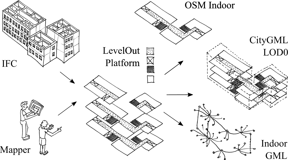
For a demonstration object, the administration center Ferdinandplatz Dresden, the building data from the construction planning are processed and completed. The implementation of a web application (LevelOut platform) will allow owners of publicly accessible buildings to make their digital building models available on the web. The web application automatically converts the uploaded data into several formats formap services, city models, and navigation models and publishes it for future use. The widely used exchange format for digital building models, FC, serves as the input format. A generic intermediate format is used to export the data formats like CityGML, IndoorGML, or OpenStreetMap.
Funding source
Project "LevelOut" is funded by the Federal Ministry for Digital and Transport (BMDV).
Duration
04/2022 – 03/2023
Budget
95.008,80 €
Project-related publications
- Tauscher, H., Heigener, D., Graichen, T., Schmidt, R., & Richter, J. 2023. IFC Georeferencing for OSM. In: Proceedings of the 18th 3D GeoInfo Conference in Conjunction with the International Forum on Urban Digital Twins (accepted). ISPRS Archives of the Photogrammetry, Remote Sensing and Spatial Information Sciences. Munic, Germany.
- Krishnakumar, S., Tauscher, H., 2023. Floor plan extraction from digital building models. In: Proceedings of FOSSGIS 2023, Berlin, Germany, 15.-18.03.2023. DOI: 10.5281/zenodo.7576205.
- Tauscher, H., Krishnakumar, S., & Heigener, D., 2022. Floor plan extraction from digital building models. In: Proceedings of the Academic Track at State of the Map 2022, Florence, Italy, 19-21.08.2022, pp. 58-61. DOI: 10.5281/zenodo.7004633.
Contact
Dr.-Ing. Helga Tauscher
Bauhaus-Universität Weimar
Informatik im Bauwesen
Coudraystrasse 13 b, Room 004
99423 Weimar
Email: helga.tauscher[at]uni-weimar.de
Phone: +49 3643 58 4214
Subhashini Krishnakumar, M.Sc.
Bauhaus-Universität Weimar
Informatik im Bauwesen
Coudraystrasse 13 b, Room 001
99423 Weimar
Email: subhashini.krishnakumar[at]uni-weimar.de
Phone: +49 3643 58 4220
Dominik Heigener, B.Sc.
Bauhaus-Universität Weimar
Informatik im Bauwesen
Coudraystraße 13 b, Room 001
99423 Weimar
Email: dominik.heigener[at]uni-weimar.de
Phone: +49 3643 584230