| (27 intermediate revisions by 10 users not shown) | |||
| Line 1: | Line 1: | ||
== Michaela: Tracking my crazy jogging trace== | == Michaela: Tracking my crazy jogging trace== | ||
There's a long distance competition for runners every autumn in Jena, the so-called Kernberglauf. It's a tricky 27 km long contest around Jena's mountainous landscape. I thought about tracking a curious route for workout one's running skills concerning speed & reactivity. | |||
Location: Jena - Kernberge (see the corner down to the right) | |||
{{ #display_map: 50.920193195343, 11.6030859947205 | {{ #display_map: 50.920193195343, 11.6030859947205 | ||
| service=openlayers | | service=openlayers | ||
| Line 18: | Line 9: | ||
}} | }} | ||
That's the house of St. Ni-cho-las (the eight syllables according to the eight parts of my trace) | |||
<gallery> | |||
File:Nicholas.jpg | |||
File:Map-2.jpg | |||
File:Map.jpg | |||
</gallery> | |||
My proposal: | |||
# Warm-up while running along the trace | |||
# Run along this trace as fast as you can | |||
# Try to enhance your speed 4 times (that's - the - house - of) & than slow it down (St. - Ni - cho - las) | |||
# Change beetwen fast (that's - house - St. - cho) and slow (the - of - Ni - las) speed | |||
# Repeat step two to four corresponding to your level of fitness: beginners - three reruns / advanced runners - up to 15 loops. Don't forget to measure your time! | |||
# Use this workout two or three times a week during your preparations for a long distance run and next to your endurance training. | |||
== Katre: 30 km/h areas in Arnstadt == | == Katre: 30 km/h areas in Arnstadt == | ||
{{ #display_map: 50.83471, 10.9474 | {{ #display_map: 50.83471, 10.9474 | ||
| service=openlayers | | service=openlayers | ||
| Line 41: | Line 34: | ||
<gallery> | <gallery> | ||
Image:OSM Karte Detail.jpg| | Image:OSM Karte Detail.jpg|Detail in OSM | ||
Image:Karte Notizen Arnstadt.jpg| | Image:Karte Notizen Arnstadt.jpg|City Map with Notes | ||
</gallery> | </gallery> | ||
== Ana, Laura and Jörg were making a Rectangle== | |||
== Ana, Laura and Jörg were making a | We tried to create/draw a rectangle by walking with a recording GPS-Device. The street around a park in Weimar gave us the pattern. | ||
{{ #display_map: 50.977812, 11.328545 | {{ #display_map: 50.977812, 11.328545 | ||
| Line 55: | Line 48: | ||
| zoom=17 | | zoom=17 | ||
}} | }} | ||
<gallery> | |||
File:rect.png|rectangle | |||
</gallery> | |||
== Henning: Ellinger near Weimar == | == Henning: Ellinger near Weimar == | ||
Took [http://maps.google.com/maps?f=q&source=s_q&hl=en&geocode=&q=Ellinger,TX&sll=37.0625,-95.677068&sspn=47.033113,93.867188&ie=UTF8&hq=&hnear=Ellinger,+Fayette,+Texas&t=h&z=15 Ellinger, TX, USA] (because it is near [http://maps.google.com/maps?f=q&source=s_q&hl=en&geocode=&q=Weimar,+TX,+USA&sll=29.839167,-96.705&sspn=0.025314,0.045834&ie=UTF8&hq=&hnear=Weimar,+Colorado,+Texas&t=h&z=15 Weimar, TX, USA]) and transfered it to the hinterland of Weimar, Germany. Then i tracked a trip to the West Train Street in Ellinger, Germany. The data was transfered to [http://www.openstreetmap.org/ openstreetmap.org], but i had pangs of conscience, so i took some pictures and restored the real data. | Took [http://maps.google.com/maps?f=q&source=s_q&hl=en&geocode=&q=Ellinger,TX&sll=37.0625,-95.677068&sspn=47.033113,93.867188&ie=UTF8&hq=&hnear=Ellinger,+Fayette,+Texas&t=h&z=15 Ellinger, TX, USA] (because it is near [http://maps.google.com/maps?f=q&source=s_q&hl=en&geocode=&q=Weimar,+TX,+USA&sll=29.839167,-96.705&sspn=0.025314,0.045834&ie=UTF8&hq=&hnear=Weimar,+Colorado,+Texas&t=h&z=15 Weimar, TX, USA]) and transfered it to the hinterland of Weimar, Germany. Then i tracked a trip to the West Train Street in Ellinger, Germany. The data was transfered to [http://www.openstreetmap.org/ openstreetmap.org], but i had pangs of conscience, so i took some pictures and restored the real data. | ||
<gallery> | <gallery> | ||
File: | File:osm 01.jpg|Ellinger, Germany on OSM | ||
File: | File:osm 02.jpg|Ellinger, Germany on OSM | ||
File: | File:josm 01.png|Cutting and Pasting data in JOSM | ||
File: | File:comparison 01.jpg|Comparison between Ellinger and Weimar | ||
File: | File:comparison 02.jpg|Comparison between Ellinger and Weimar | ||
File: | File:comparison 05.jpg|Comparison between Ellinger and Weimar | ||
</gallery> | </gallery> | ||
== Henning: Urban Tic-Tac-Toe == | == Henning: Urban Tic-Tac-Toe == | ||
I played a game of Tic-Tac-Toe with a friend via SMS. Due to the design and lay-out of a the roads in my neighborhood i thought it would be a good playing field. So i tracked me running through the backyards reconstructing the run of play of our Tic-Tac-Toe match on the new playing field. | I played a game of Tic-Tac-Toe with a friend via SMS. Due to the design and lay-out of a the roads in my neighborhood i thought it would be a good playing field. So i tracked me running through the backyards reconstructing the run of play of our Tic-Tac-Toe match on the new playing field. | ||
<gallery> | <gallery> | ||
File:ttt.png|GPS track of the game | File:ttt.png|GPS track of the game | ||
File: | File:ttt conversation.png|Run of play | ||
File: | File:ttt field.png|Playing field | ||
File: | File:ttt 01.jpg|Backyard | ||
File: | File:ttt 02.jpg|Cat looking at me | ||
File: | File:ttt 03.jpg|Trierer Straße | ||
File:ttt 04.jpg|Unconquerable garages | |||
</gallery> | </gallery> | ||
== Moritz und Frederic: Weltreise == | == Moritz und Frederic: Weltreise == | ||
We did a journey around the globe and took some nice pics! We uploaded them on google earth so you can check the places we've been. Let's see if google will accept our pics so our journey will be officially done... | |||
[[File:Egypt.jpg|600px]] | |||
<gallery> | |||
File:Weltreis.jpg|uploading pics | |||
File:weimar.jpg|we've been in: weimar, | |||
File:cheops.jpg|egypt, | |||
File:moskau.jpg|moscow, | |||
File:sydney.jpg|sydney, | |||
File:rio.jpg|rio, | |||
File:newyork.jpg|new york | |||
File:greenland.jpg|and greenland! | |||
</gallery> | |||
== Gesine ::pimp an island:: == | |||
transform gough island (atlantic ocean) into sesamstraße island | |||
[[File: | <gallery> | ||
File:Island1.jpg|step1 | |||
File:Island2.jpg|step2 | |||
File:Island4.jpg|step3 add sesam-airport | |||
File:Island5.jpg|step4 add pub-mumpitz | |||
File:Island6.jpg|step5 add police lulatsch | |||
File:Island7.jpg|step6 add ferry terminal gorbi | |||
File:Island8.jpg|step7 | |||
File:Island9.jpg|step8 | |||
File:Island10.jpg|step9 metro | |||
File:Island11.jpg|step10 | |||
File:Island12.jpg|step11 | |||
File:Island14.jpg|step12 add a lot | |||
File:Island15.jpg|step13 | |||
File:Island16.jpg|step14 | |||
File:Island17.jpg|step15 sesamstraße island is already pimped | |||
</gallery> | |||
== liana : bus linie 1 == | |||
bus track that I should take if I want to go to Hauptbahnhof Weimar | |||
{{ | |||
#display_map: | |||
50.98387, 11.32628 | |||
| service=openlayers | |||
| layers=osm-oepnv,osm-mapnik,osmarender,osm-cyclemap,bing | |||
| zoom=15 | |||
}} | |||
<gallery> | |||
File:Routebuslinie1.jpg|track | |||
</gallery> | |||
== marianne: Rapunzels tower == | |||
there's a new tourist sight in Weimar Ilm Park! | |||
[[File:rapunzels tower.jpg|700px]] | |||
I only have the picture of the editing mode out of JOSM because it's not shown in OSM (jet?) | |||
== Gentian: Walking in City == | |||
I walk around the city center in Weimar, and I record my tracks with GPS. Than I edit recorded track in JOSM Editor, and finally I put it online in OSM. | |||
[[File:JOSM5.jpg|600px]] | |||
<gallery> | <gallery> | ||
File:JOSM1.jpg|Pasting data in JOSM Editor, | |||
File:JOSM2.jpg|Rewriting the line in JOSM Editor, | |||
File:JOSM3.jpg|JOSM Editor - Imagery OpenStreetMap, | |||
File:JOSM4.jpg|JOSM Editor - Imagery OpenStreetMap1, | |||
File:OSM.jpg|Online editing in OSM | |||
</gallery> | </gallery> | ||
Latest revision as of 17:37, 15 April 2012
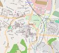
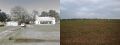
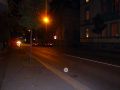
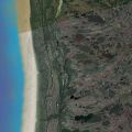
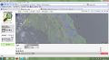
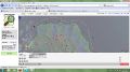
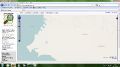
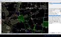
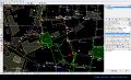
Michaela: Tracking my crazy jogging trace
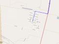
There's a long distance competition for runners every autumn in Jena, the so-called Kernberglauf. It's a tricky 27 km long contest around Jena's mountainous landscape. I thought about tracking a curious route for workout one's running skills concerning speed & reactivity.
Location: Jena - Kernberge (see the corner down to the right) {{ #display_map: 50.920193195343, 11.6030859947205 | service=openlayers | layers=osm-mapnik,osmarender,osm-cyclemap | zoom=14 }}
That's the house of St. Ni-cho-las (the eight syllables according to the eight parts of my trace)


My proposal:
- Warm-up while running along the trace
- Run along this trace as fast as you can
- Try to enhance your speed 4 times (that's - the - house - of) & than slow it down (St. - Ni - cho - las)
- Change beetwen fast (that's - house - St. - cho) and slow (the - of - Ni - las) speed
- Repeat step two to four corresponding to your level of fitness: beginners - three reruns / advanced runners - up to 15 loops. Don't forget to measure your time!
- Use this workout two or three times a week during your preparations for a long distance run and next to your endurance training.
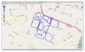
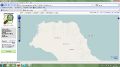
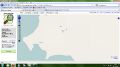
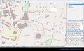
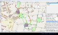
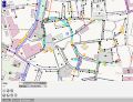
Katre: 30 km/h areas in Arnstadt
{{ #display_map: 50.83471, 10.9474 | service=openlayers | layers=osm-mapnik,osmarender,osm-cyclemap,osm-oepnv | zoom=15 }} I marked with JOSM all areas in Arnstadt, where max speed is 30 km/h
Detail in OSM
City Map with Notes


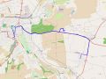
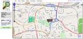
Ana, Laura and Jörg were making a Rectangle
We tried to create/draw a rectangle by walking with a recording GPS-Device. The street around a park in Weimar gave us the pattern.
{{ #display_map: 50.977812, 11.328545 | service=openlayers | layers=osm-mapnik | width=500 | height=500 | zoom=17 }}
rectangle

Henning: Ellinger near Weimar
Took Ellinger, TX, USA (because it is near Weimar, TX, USA) and transfered it to the hinterland of Weimar, Germany. Then i tracked a trip to the West Train Street in Ellinger, Germany. The data was transfered to openstreetmap.org, but i had pangs of conscience, so i took some pictures and restored the real data.
Ellinger, Germany on OSM
Ellinger, Germany on OSM
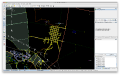
Cutting and Pasting data in JOSM
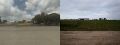
Comparison between Ellinger and Weimar
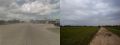
Comparison between Ellinger and Weimar
Comparison between Ellinger and Weimar


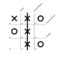
Henning: Urban Tic-Tac-Toe
I played a game of Tic-Tac-Toe with a friend via SMS. Due to the design and lay-out of a the roads in my neighborhood i thought it would be a good playing field. So i tracked me running through the backyards reconstructing the run of play of our Tic-Tac-Toe match on the new playing field.
GPS track of the game

Run of play
Playing field

Backyard
Cat looking at me
Trierer Straße
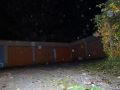
Unconquerable garages


Moritz und Frederic: Weltreise
We did a journey around the globe and took some nice pics! We uploaded them on google earth so you can check the places we've been. Let's see if google will accept our pics so our journey will be officially done...


uploading pics
we've been in: weimar,

egypt,

moscow,

sydney,

rio,
new york

and greenland!


Gesine ::pimp an island::
transform gough island (atlantic ocean) into sesamstraße island
step1
step2

step3 add sesam-airport
step4 add pub-mumpitz
step5 add police lulatsch
step6 add ferry terminal gorbi
step7

step8
step9 metro
step10
step11
step12 add a lot
step13

step14

step15 sesamstraße island is already pimped


liana : bus linie 1
bus track that I should take if I want to go to Hauptbahnhof Weimar
{{
- display_map:
50.98387, 11.32628 | service=openlayers | layers=osm-oepnv,osm-mapnik,osmarender,osm-cyclemap,bing | zoom=15 }}
track

marianne: Rapunzels tower
there's a new tourist sight in Weimar Ilm Park!

I only have the picture of the editing mode out of JOSM because it's not shown in OSM (jet?)
Gentian: Walking in City
I walk around the city center in Weimar, and I record my tracks with GPS. Than I edit recorded track in JOSM Editor, and finally I put it online in OSM.

Pasting data in JOSM Editor,
Rewriting the line in JOSM Editor,
JOSM Editor - Imagery OpenStreetMap,
JOSM Editor - Imagery OpenStreetMap1,
Online editing in OSM


