Glozt100sob (talk | contribs) |
Glozt100sob (talk | contribs) |
||
| (19 intermediate revisions by the same user not shown) | |||
| Line 1: | Line 1: | ||
IMPORTANT!!:please kindly download full project description from the link below: | |||
[[Media:Relieve_Climate_iOS_Application_WS_11.pdf]] | |||
==Relieve Climate Synopsis== | ==Relieve Climate Synopsis== | ||
| Line 19: | Line 22: | ||
==Demonstration Phase and Target Audience== | ==Demonstration Phase and Target Audience== | ||
<br> | <br> | ||
*For the alpha (prototype phase), the application focuses integrating in public | *For the alpha (prototype phase), the application focuses integrating in public skytrain in Bangkok, Thailand namely BTS(Bangkok Mass Transit System) Skytrain. | ||
*The application focuses on iOS smart device holders, soon, on Android OS and etc. | *The application focuses on iOS smart device holders, soon, on Android OS and etc. | ||
*The target application | *The main target application is a motorist who rarely take BTS Skytrain. However, daily or repetitive passengers are also in target group. | ||
==Relieve Climate Features and USPs== | |||
<br> | |||
*'''Real-time Portable Data Tracker: ''' '''Relieve Climate''' is an application which installed in mobile device and able to immediately synthesize the visualization once finishing tracking the data. To view user own data, no need to connect to personal computer or laptop. | |||
''' | *'''Ease to use: ''' According to Human Interface Guide (HIG) which is a document that Apple distributes for guidance in developing iPhone Apps for sale on the App Store. '''Relieve Climate''' perfectly follow rules and restrictions in HIG, as a result, the application is easy to use and no instruction is required. | ||
*'''QR-Code Reader embedded: ''' '''Relieve Climate''' uses Zxing(pronounced zebra crossing) QR-Code scanner library which provides powerful scanner function via mobile camera. Quick and easy scanning are applicable perfectly to application. | |||
*'''GPS and Mapkit embedded: ''' To view current position while checking-in, Mapkit used for previewing a position on Google map. Furthermore, GPS device can also inform exact position of user. | |||
*'''Brain Train Tip Feature: ''' The application provides brain improvement while user get involved to application. For example, while users is activating journey, they are able to read hints of idea which provide a little knowledge according to general subject in our life such as health, sciences, history, life style and etc. | |||
==Relieve Climate Concept Approach== | |||
Below teaser video illustrates about how Relieve Climate works. | |||
<videoflash type=vimeo>36056740|518|245</videoflash> | |||
To revise my first concept of this project you may want to visit [http://www.uni-weimar.de/medien/wiki/IFD:Showreel/Patawat_Phamuad_-_Relieve_Climate Interface design showreel] | |||
==Test Run and Result of Project== | |||
First experiment using Relieve Climate application running on iPad II iOS 4.2 at the real site, I experimented at the train station in Weimar, traveled to Jena Germany. To test an accuracy of GPS, I set the most accurated GPS indicator. The distance between Weimar and Jena is 23 kms and spent approximately 24 minutes long. The details of test run are explained as below: | |||
<br> | |||
<br> | |||
<videoflash type=vimeo>38131128|518|245</videoflash> | |||
<br> | <br> | ||
* | *Once I opened the application, Relieve Climate was launced and splash screen worked properly lasting 3 seconds. | ||
*To activate QR-Code scanner, I touched the ‘Check-in Journey’ button and QR-Code scanner worked properly. The application called iOS device’s camera viewfinder by ImagePicker subclass from UIKit superclass in iOS programming section. | |||
*To scan the QR-Code, I scanned the QR-Code via the viewfinder. Not over than 1 second, QR-Code was detected. I tested from the distance between iOS device and QR-Code sign from 1 meter to 7 meters, the scanner worked accurately. | |||
*After scanning QR-Code, GPS navigator indicated the current user postion accurately. Sometimes, location pin swinged at the beginning and the distance indicator was unstable between 1 meter - 5 meters. According to the Apple Developer community, plenty of developer complained this GPS instability. Finally, in iOS 4.3 this problem was dissolved by Apple Inc. | |||
* | *While traveling, GPS navigator worked properly, however, somewhere, where was lack of signal causing inaccurated distance evaluation. | ||
* | *‘Brain Train Tip’ feature recalled properly and did not affect to main process. | ||
* | *When arrived at arrival station Jena, a journey result was evaluated properly, eventhough, Carbon Dioxide quantity result slightly deviated from bahn.de reference. | ||
* | *A data visualization part typically worked. A number of diamond evaluated correctly according to mathematic formular which applied in the programming code. | ||
==Relieve Climate Screenshots== | ==Relieve Climate Screenshots== | ||
| Line 66: | Line 83: | ||
</gallery> | </gallery> | ||
==Relieve Climate | ==Data | Story | Visualization== | ||
Relieve Climate utilises the meta-data that is being created by the application usage of occasionally or everyday. The digital data produced from regular application usage is transformed in an interesting way. Diamond shapes are visualized at the end of successful use. | |||
'''Why diamond?''' | |||
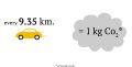
If we kindly discuss about Carbon Dioxide emission, using BTS public transport trip is a solution to less emit Carbon Dioxide to the atmosphere. Moreover, If we look closely to Carbon Dioxide molecule, we would discover that Carbon Dioxide gas contains with 1 atom Carbon and 2 atoms Oxigen. Interestingly, when many Carbon atoms are bonded together with covalent bond, it would form a hard substance, which could be reformed to a diamond shape. That means the more Carbon Dioxide saved, the more diamonds and Oxigen gases would be produced. | |||
[[File:Patawat_Phamuad_Relieve_Climate_17.jpg|Why diamond?|600 px]] | |||
The amount of diamond that collected in application database(memory), could be encoded to a digital binary code. User is able to exchange that code with a physical reward from BTS counter service i.e. a souvenir, soft drink, movie ticket, promotion coupon, gift voucher and etc. This is a push and pull marketing technique which has already well succeeded in many businesses. What is the benefit of these archives are not only for individual but also affect to social and environmental aspects. Even more Relieve Climate is taken part, even more environment is practically improved! | |||
==You want to try Relieve Climate?== | |||
I appreciate if you would like to try Relieve Climate. For further information about installing the application or if you have a question about the project. Please feel free to contact me at patawat.phamuad@uni-weimar.de | |||
Now let's begin with an installation. | |||
'''What do you need?''' | |||
< | 1. You need iOS device 3rd or 4th generation: iPhone3, iPhone4, iPhone 4S, iPod Touch 3G, iPod Touch 4G and iPad I&II. which has GPS navigator embedded. And, data connection cable. Your device iOS must be iOS 3.0 or later.<br> | ||
2. MacOS device i.e. Macbook, Macbook Pro, iMac, Mac mini or PC which able to run MacOS.<br> | |||
3. iOS Developer account.<br> | |||
4. Xcode IDE.<br> | |||
'''How can you install Relieve Climate?''' | |||
At the present development phrase, Relieve Climate now is not available on App store but soon. Therefore, what you need to do are: | |||
1. Follow fundamental [[iOSDev]] instruction to setup Xcode and obtain your code sign. <br> | |||
2. Connect your iOS device with your Mac by datalink cable.<br> | |||
3. Download [http://dl.dropbox.com/u/30247554/zxing-1.6.zip/ Relieve Climate project]. Then locate downloaded file to your hard drive. | |||
''IMPORTANT!: Relieve Climate project folder must be located in zxing-1.6/iphone folder.'' | |||
4. Open RelieveClimate.xcodeproj <br> | |||
5. Build and Run project by debugging on device. The project can also run in Simulator but cannot enable QR-Code scanner. ;'( <br> | |||
==Project References== | |||
''Project Inquiry and inspiration::'' | |||
*[http://infosthetics.com/archives/2009/08/the_sustainability_of_train_travel_versus_other_transportation_means.html The Sustainability of train versus other transportation on means-Deutsche Bahn] | |||
''Technologies::'' | |||
*[https://developer.apple.com/ I. iOS SDK] | |||
*[https://developer.apple.com/library/ios/navigation/ II. iOS Developer Libraries] | |||
*[https://developer.apple.com/xcode/index.php/ III. Xcode IDE] | |||
*[http://code.google.com/p/zxing/ IV. Zxing (Zebra-Crossing) QR-Code library for iOS ] | |||
*[http://box2d.org/ V. Box2D Physics engine ] | |||
''Referred document resources::'' | ''Referred document resources::'' | ||
Definition and measures of Mobility Management | |||
*[http://www.epomm.eu/ I. European Platform on Mobility Management.] | |||
*[https://sites.google.com/site/managingmobility/mobilitymanagement101 II. Mobility Management Website] | |||
Bangkok Transit System (BTS) Fact sheets | Bangkok Transit System (BTS) Fact sheets | ||
| Line 128: | Line 152: | ||
*[http://www.thaiauto.or.th/statistic/motorcycle_sales.asp III.Vehicle sales table in 1993-2011.] | *[http://www.thaiauto.or.th/statistic/motorcycle_sales.asp III.Vehicle sales table in 1993-2011.] | ||
*[http://th.wikipedia.org/wiki/%E0%B8%81%E0%B8%A3%E0%B8%B8%E0%B8%87%E0%B9%80%E0%B8%97%E0%B8%9E%E0%B8%A1%E0%B8%AB%E0%B8%B2%E0%B8%99%E0%B8%84%E0%B8%A3%E0%B9%81%E0%B8%A5%E0%B8%B0%E0%B8%9B%E0%B8%A3%E0%B8%B4%E0%B8%A1%E0%B8%93%E0%B8%91%E0%B8%A5 IV.Bangkok Metropolitan Region] | *[http://th.wikipedia.org/wiki/%E0%B8%81%E0%B8%A3%E0%B8%B8%E0%B8%87%E0%B9%80%E0%B8%97%E0%B8%9E%E0%B8%A1%E0%B8%AB%E0%B8%B2%E0%B8%99%E0%B8%84%E0%B8%A3%E0%B9%81%E0%B8%A5%E0%B8%B0%E0%B8%9B%E0%B8%A3%E0%B8%B4%E0%B8%A1%E0%B8%93%E0%B8%91%E0%B8%A5 IV.Bangkok Metropolitan Region] | ||
==Data Collecting Experiment== | ==Data Collecting Experiment== | ||
| Line 243: | Line 264: | ||
to download example sketches click link below: | to download example sketches click link below: | ||
[[Media:dataCollectingCo2.zip]] | [[Media:dataCollectingCo2.zip]] | ||
{{Template:CC_Patawat}} | |||
Latest revision as of 17:12, 16 March 2012
 IMPORTANT!!:please kindly download full project description from the link below:
 Media:Relieve_Climate_iOS_Application_WS_11.pdf
Relieve Climate Synopsis
Problem
At the present day, people rely on personal comfort than responding to environment issue. As a result, using private vehicles:- cars, motorcycle not only making more air pollution than taking a train or railway system but also consuming more energy and fuel respectively. Furthermore, traffic jam problem in a metropolis is accordingly caused by high increase rate of personal vehicles. Beside, main emission from vehicles' engine fuel ignition are Carbon Dioxide gas which able to severely damage human respiratory system. Last but not least, exhaust gases aka. Green House gases:- Carbon Dioxide and Carbon Monoxide are the majority cause of climate change and global warming.
See how is nowadays Global Warming situation via the video below:
<videoflash type=vimeo>32591989|518|245</videoflash>
An Inconvenient Truth: Albert Arnold "Al" Gore, Jr.
video credit: http://vimeo.com/buck
Project Objective
I introduce an iOS application namely Relieve Climate ,which supports Mobility Management (MM). Mobility Management measures is a pull, a new concept in a developed country is expected to effectively manage the growing amount of private car. The main idea is to give knowledge or publicity information related to travel through the cooperation between various departments. Along with the use of tools or measures to encourage motorists to change their attitudes and behavior on the trip (Voluntary Behavior Change). Relieve Climate responds to impulse daily car users to get involved to public transportation focusing on Bangkok Transit System (BTS) skytrain located in Bangkok Thailand. The application continuously keeps tracking user's trip data presenting in a quantity of saved Carbon Dioxide. After that, visualizes the data to become semi-tangible graphic on the device’s interface. Furthermore, marketing technique is a key implemented to this Mobility Management. As a result , the applicants who cumulatively collect a bunch of Carbon Dioxide data would be rewarded with a prize from official sponsors collaborating with BTS skytrain. The expect result of the application is demanding less car use and convinced to take a public transport.
Demonstration Phase and Target Audience
- For the alpha (prototype phase), the application focuses integrating in public skytrain in Bangkok, Thailand namely BTS(Bangkok Mass Transit System) Skytrain.
- The application focuses on iOS smart device holders, soon, on Android OS and etc.
- The main target application is a motorist who rarely take BTS Skytrain. However, daily or repetitive passengers are also in target group.
Relieve Climate Features and USPs
- Real-time Portable Data Tracker: Relieve Climate is an application which installed in mobile device and able to immediately synthesize the visualization once finishing tracking the data. To view user own data, no need to connect to personal computer or laptop.
- Ease to use: According to Human Interface Guide (HIG) which is a document that Apple distributes for guidance in developing iPhone Apps for sale on the App Store. Relieve Climate perfectly follow rules and restrictions in HIG, as a result, the application is easy to use and no instruction is required.
- QR-Code Reader embedded: Relieve Climate uses Zxing(pronounced zebra crossing) QR-Code scanner library which provides powerful scanner function via mobile camera. Quick and easy scanning are applicable perfectly to application.
- GPS and Mapkit embedded: To view current position while checking-in, Mapkit used for previewing a position on Google map. Furthermore, GPS device can also inform exact position of user.
- Brain Train Tip Feature: The application provides brain improvement while user get involved to application. For example, while users is activating journey, they are able to read hints of idea which provide a little knowledge according to general subject in our life such as health, sciences, history, life style and etc.
Relieve Climate Concept Approach
Below teaser video illustrates about how Relieve Climate works.
<videoflash type=vimeo>36056740|518|245</videoflash>
To revise my first concept of this project you may want to visit Interface design showreel
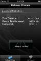
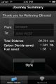
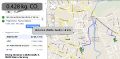
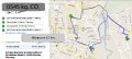
Test Run and Result of Project
First experiment using Relieve Climate application running on iPad II iOS 4.2 at the real site, I experimented at the train station in Weimar, traveled to Jena Germany. To test an accuracy of GPS, I set the most accurated GPS indicator. The distance between Weimar and Jena is 23 kms and spent approximately 24 minutes long. The details of test run are explained as below:
<videoflash type=vimeo>38131128|518|245</videoflash>
- Once I opened the application, Relieve Climate was launced and splash screen worked properly lasting 3 seconds.
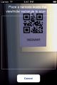
- To activate QR-Code scanner, I touched the ‘Check-in Journey’ button and QR-Code scanner worked properly. The application called iOS device’s camera viewfinder by ImagePicker subclass from UIKit superclass in iOS programming section.
- To scan the QR-Code, I scanned the QR-Code via the viewfinder. Not over than 1 second, QR-Code was detected. I tested from the distance between iOS device and QR-Code sign from 1 meter to 7 meters, the scanner worked accurately.
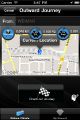
- After scanning QR-Code, GPS navigator indicated the current user postion accurately. Sometimes, location pin swinged at the beginning and the distance indicator was unstable between 1 meter - 5 meters. According to the Apple Developer community, plenty of developer complained this GPS instability. Finally, in iOS 4.3 this problem was dissolved by Apple Inc.
- While traveling, GPS navigator worked properly, however, somewhere, where was lack of signal causing inaccurated distance evaluation.
- ‘Brain Train Tip’ feature recalled properly and did not affect to main process.
- When arrived at arrival station Jena, a journey result was evaluated properly, eventhough, Carbon Dioxide quantity result slightly deviated from bahn.de reference.
- A data visualization part typically worked. A number of diamond evaluated correctly according to mathematic formular which applied in the programming code.
Relieve Climate Screenshots
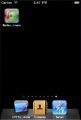
Relieve Climate#1

Relieve Climate#2
Relieve Climate#3
Relieve Climate#4
Relieve Climate#5

Relieve Climate#6
Relieve Climate#7

Relieve Climate#8


Data | Story | Visualization
Relieve Climate utilises the meta-data that is being created by the application usage of occasionally or everyday. The digital data produced from regular application usage is transformed in an interesting way. Diamond shapes are visualized at the end of successful use.
Why diamond?
If we kindly discuss about Carbon Dioxide emission, using BTS public transport trip is a solution to less emit Carbon Dioxide to the atmosphere. Moreover, If we look closely to Carbon Dioxide molecule, we would discover that Carbon Dioxide gas contains with 1 atom Carbon and 2 atoms Oxigen. Interestingly, when many Carbon atoms are bonded together with covalent bond, it would form a hard substance, which could be reformed to a diamond shape. That means the more Carbon Dioxide saved, the more diamonds and Oxigen gases would be produced.

The amount of diamond that collected in application database(memory), could be encoded to a digital binary code. User is able to exchange that code with a physical reward from BTS counter service i.e. a souvenir, soft drink, movie ticket, promotion coupon, gift voucher and etc. This is a push and pull marketing technique which has already well succeeded in many businesses. What is the benefit of these archives are not only for individual but also affect to social and environmental aspects. Even more Relieve Climate is taken part, even more environment is practically improved!
You want to try Relieve Climate?
I appreciate if you would like to try Relieve Climate. For further information about installing the application or if you have a question about the project. Please feel free to contact me at patawat.phamuad@uni-weimar.de
Now let's begin with an installation.
What do you need?
1. You need iOS device 3rd or 4th generation: iPhone3, iPhone4, iPhone 4S, iPod Touch 3G, iPod Touch 4G and iPad I&II. which has GPS navigator embedded. And, data connection cable. Your device iOS must be iOS 3.0 or later.
2. MacOS device i.e. Macbook, Macbook Pro, iMac, Mac mini or PC which able to run MacOS.
3. iOS Developer account.
4. Xcode IDE.
How can you install Relieve Climate?
At the present development phrase, Relieve Climate now is not available on App store but soon. Therefore, what you need to do are:
1. Follow fundamental iOSDev instruction to setup Xcode and obtain your code sign.
2. Connect your iOS device with your Mac by datalink cable.
3. Download Relieve Climate project. Then locate downloaded file to your hard drive.
IMPORTANT!: Relieve Climate project folder must be located in zxing-1.6/iphone folder.
4. Open RelieveClimate.xcodeproj
5. Build and Run project by debugging on device. The project can also run in Simulator but cannot enable QR-Code scanner. ;'(
Project References
Project Inquiry and inspiration::
Technologies::
- I. iOS SDK
- II. iOS Developer Libraries
- III. Xcode IDE
- IV. Zxing (Zebra-Crossing) QR-Code library for iOS
- V. Box2D Physics engine
Referred document resources::
Definition and measures of Mobility Management
Bangkok Transit System (BTS) Fact sheets
Emissions of carbon dioxide per capital
Automotive Statistics
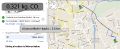
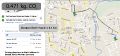
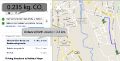
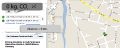
Data Collecting Experiment
This section I would like to describe about my first experiment with data collecting. During Monday 14.11 to Sunday 20.11, I collected the data from roughly measurement distances between the places I had been in each day. After that, I jot down how far distances I travelled then calculated into amount of Carbon Dioxide, which I was able to save. Please look at the illustrators below:
approximately Co2 released rate
Data Collected on Monday 14.11 and Tuesday 15.11
Data Collected on Wednesday 16.11
Data Collected on Thursday 17.11
Data Collected on Friday 18.11
Data Collected on Saturday 19.11
Data Collected on Sunday 20.11


When the datas were adequately collected. The datacollect.tsv was set up as in row and column as below:

I made a sketch which visualize the datas, which i collected. The sketch represented in bubble animation form using sin() function and each circles' color represents the day when I collected the informations. In addition, maximum size of growing circle informs how much Co2 rate, I could save. Lastly, the circles are randomly located by random() function with array[]. See my several visualized datas as pictures below:


dataCollectingCo2 sketch example code
/* data visualization :: How much I can save Co2 releasing in 1 week.
 *
 * an experiment from collecting the data then visualize these datas to motion graphic.
 *
 *
 * Patawat Phamuad 2011
 */

Table dataTable;
int numCircles=7;
int rowCount;
float rad = 20f;
float angle = 0.0f;
float speed = 0.01;

float[] xPositions = new float[numCircles];
float[] yPositions = new float[numCircles];

void setup() {
  size(300, 300);
  noStroke();
  smooth();

  dataTable = new Table("datacollect.tsv");
  rowCount = dataTable.getRowCount();

  for (int i=0; i< numCircles; i++) {
    xPositions[i] = random(0, width);
    yPositions[i] = random(0, height);
  }
}

void draw() {
  background(0);
  angle += speed;
  float diameter = sin(angle)*300;
  for (int row=0;row<rowCount;row++) {

    String date = dataTable.getString(row, 0);
    float distance = dataTable.getFloat(row, 1);
    float co2 = dataTable.getFloat(row, 2);

    if (row==0) {
      fill(255, 255, 0, 155);
      ellipse(xPositions[row], yPositions[row], diameter*co2, diameter*co2);
    }
    else if (row==1) {
      fill(234, 114, 234, 155);
      ellipse(xPositions[row], yPositions[row], diameter*co2, diameter*co2);
    }
    else if (row==2) {
      fill(42, 165, 27, 155);
      ellipse(xPositions[row], yPositions[row], diameter*co2, diameter*co2);
    }
    else if (row==3) {
      fill(232, 84, 26, 155);
      ellipse(xPositions[row], yPositions[row], diameter*co2, diameter*co2);
    }
    else if (row==4) {
      fill(15, 8, 255, 155);
      ellipse(xPositions[row], yPositions[row], diameter*co2, diameter*co2);
    }
    else if (row==5) {
      fill(121, 13, 180, 155);
      ellipse(xPositions[row], yPositions[row], diameter*co2, diameter*co2);
    }
    else if (row==6) {
      fill(255, 0, 0, 155);
      ellipse(xPositions[row], yPositions[row], diameter*co2, diameter*co2);
    }
    println("Date:" +date+ " Total distance:" +distance+" km."+ " Co2 Safe:"+co2 +" kg.");
  }

  println("========");
  println(rowCount);
}
to download example sketches click link below: Media:dataCollectingCo2.zip

Relieve Climate by Patawat Phamuad is licensed under Creative Commons Attribution-NonCommercial-NoDerivs 3.0 Unported License