GMU:On Psychogeography and Architecture/Projektideen/Michael: Difference between revisions
| Line 25: | Line 25: | ||
==Process/Discoveries== | ==Process/Discoveries== | ||
In addition to photographing residences, I chose to document each endhaltestelle by looking objects/spaces that that could be considered landmarks, places of commerce, or connecting points to further destinations. Unlike the "center" of Weimar, there are few monuments, recognizable street names, or landmarks that offer/cultivate a sense of place. In part, I hope to remove/disabuse the sense of anonymity surrounding these spaces and challenge the ability to read, interpret-- in essence to ''know''--a place. Additionally, I decided to shoot at the same time every day, just before dusk, in between the time when most people return home from work and the departure of the last bus to the center of Weimar so as to examine each space under the same conditions and to note their differences accordingly. The spaces surrounding each endhaltestelle ran the gamut from well-manicured, seemingly pre-fabricated communities (archetypal "suburban" space) to spaces with no ostensible logic/design; from austral spaces, to residential ones, to those in between. The resulting photographs serve as traces of both my journeys and sojourns. | |||
Revision as of 23:36, 11 February 2013
ENDHALTESTELLE
Concept
Most of Weimar's approximately sixty thousand inhabitants reside beyond what might be deemed the "city center. Endhaltestelle investigates communities on the supposed outskirts of Weimar as defined by its public transportation system. Apart from those established by local government and city planning officials, how do we draw the lines of a city? How are flexible are those boundaries or, in other words, where does the city begin and where does it end? Specifically, what can be said about the neighborhoods/places that circumscribe the inner city--those rarely traversed by non-residents? Endhaltestelle aims to explore the fluidity of urban/peripheral space by documenting the area surrounding the end of each bus line.
Inspiration
In his seminal work, The Production of Space, Henri Lefebreve writes, "It is not only the codes — the map’s legend, the conventional signs of map-making and map-reading — that are liable to change, but also the objects represented, the lens through which they are viewed and the scale used. We are confronted not by one social space but by many indeed, by an unlimited multiplicity or unaccountable set of ocial spaces."
As a native of a large city, one with an extensive and well-utilized transportation system, I am drawn to the discrepancies between maps that represent and delineate space and urban space itself. Cities are not static and neither are the people who inhabit them. Like people, cities are mobile and kinetic, and a city's public transportation system can serve as a valuable criterion for observing and understanding urban space. If one is to feel that ones "knows" a city, then exactly how much of it must one "know?" While maps attempt to organize space, such that space becomes legible, in many cases, to the contrary, they obscure space. The Weimar Netzplan is as byzantine a matrix of multicolored lines, numbers and symbols as the metro maps of London, Paris and New York. Yet spatially and demographically, Weimar is unlike any of the aforementioned cities.
Additionally, I was interested in the restricted access to and from the end of each bus line. For each endhaltestelle, there is a moratorium on service after a certain hour (sometimes quite early in the evening), at which point travel options to and from these areas are limited while buses continue to operate within the "city center". I was curious as to the ramifications of the limited hours of operation. How does such limited access to public transportation affect the communities at the end of each bus line?
- Error creating thumbnail: File missing
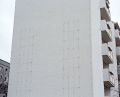
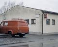
Große Gebäude
- Error creating thumbnail: File missing
Landmarke
- Error creating thumbnail: File missing
Mobilität
Wand
Lebensmittel


Process/Discoveries
In addition to photographing residences, I chose to document each endhaltestelle by looking objects/spaces that that could be considered landmarks, places of commerce, or connecting points to further destinations. Unlike the "center" of Weimar, there are few monuments, recognizable street names, or landmarks that offer/cultivate a sense of place. In part, I hope to remove/disabuse the sense of anonymity surrounding these spaces and challenge the ability to read, interpret-- in essence to know--a place. Additionally, I decided to shoot at the same time every day, just before dusk, in between the time when most people return home from work and the departure of the last bus to the center of Weimar so as to examine each space under the same conditions and to note their differences accordingly. The spaces surrounding each endhaltestelle ran the gamut from well-manicured, seemingly pre-fabricated communities (archetypal "suburban" space) to spaces with no ostensible logic/design; from austral spaces, to residential ones, to those in between. The resulting photographs serve as traces of both my journeys and sojourns.